The Delmarva Peninsula occupies portions of three states. Its named is formed from letters from Delaware, Maryland and Virginia.
At the northern point of the peninsula there is a geographic fall line that separates the crystalline rocks of the Piedmont from the unconsolidated sediments of the Coastal Plain. This line passes through Newark and Wilmington, Delaware and Elkton, Maryland.
The peninsula has a land area of nearly 6,000 square miles. There are 2000 miles of coastline for the Chesapeake Bay, 381 miles for the Delaware Bay and 150 miles coastline on the Atlantic Ocean. The highest elevation is 400 feet with most of the peninsula being at 35 feet above sea level.
The oldest English settlements of the area were settled as part of the Virginia Colony. The peninsula was explored by John Smith during his exploration of the Chesapeake Bay beginning in 1608. He was the first European to chart the area.
In 1631 the Colony of Maryland was chartered to Cæcilius Calvert giving him the rights to lands North of the Potomac River and east of the Chesapeake Bay to the Delaware River and Bay.
This was followed in 1681 when William Penn was given a Charter for Pennsylvania that included the land area now known as Delaware with portions of the peninsula under the control of three British Colonies.
For the first 150 years of the English settlement the peninsula colonial borders were questioned. Maryland felt that the entire peninsula north of the Potomac parallel should be part of the Maryland Colony. The borders between Maryland and Delaware were finally established by the Surveyors Charles Mason and Jeremiah Dixon in 1767.
While the Fall Line is the scientific border of the Delmarva Peninsula, for the purpose of this page the northern border of Delmarva will be considered to be the Chesapeake & Delaware Canal. The canal connects the Delaware and the Chesapeake Bays crossing the peninsula just south of the Fall Line and creates a man-made waterway making the peninsula south of the canal an Island.
Almost from the time that the peninsula was first settled a canal to cross the peninsula between the Delaware River and the Chesapeake Bay was a topic of consideration. Augustine Herman was the first proposed to a canal. Herman was a mapmaker and developed one of the first maps of the upper Delmarva for the Calvert’s of Maryland.
It wasn’t until the late 18th century that surveys of possible water routes were made. Benjamin Franklin was part of a group that looked into the possibility.
In 1802 the Chesapeake and Delaware Canal Company was incorporated. Construction began in 1814, but a lack of funds forced the project to be stopped in 1816. In 1822 the canal company reorganized and received monetary support from Pennsylvania, Maryland, Delaware and the Federal Government. Work began commenced again in April 1824 with the canal opening in 1829. The total cost was nearly 2.5 million dollars.
The canal of 1829 was much different than it is today. When it opened it was 14 miles long, 10 feet deep, 66 feet wide at the water line and 36 feet at the bottom. Locks existed at Delaware City and St. Georges, Delaware as well as two at Chesapeake City, Maryland.
In 1919, the Federal Government purchased the canal. From 1921 to 1927 the Army Corps of Engineers converted it to a sea-level canal by widening it, and removing all of the locks.
Today the canal is 450 feet wide with a depth of 35 feet. The canal is a modern sea-level commercial waterway that carries about 40 percent of the ship traffic to the Port of Baltimore.
The Delmarva Peninsula from the C&D canal to southern point at the tip of the Eastern Shore of Virginia is about 180 miles. At its widest it’s about 60 miles, although most of the peninsula is much narrower.
The other bodies of waters surrounding the peninsula are to the east, the Delaware Bay, the Delaware River and the Atlantic Ocean; to the west is the Chesapeake Bay and to the South the mouth of the Chesapeake Bay as it flows into the Atlantic Ocean.
The western or Chesapeake Bay coast is indented and marshy. The eastern coast is more regular with sandy beaches, especially along the Atlantic Ocean.
There are 5 bridges that cross over the C&D canal. These are at Maryland 213, Delaware 896, US 13, Delaware 1 and Delaware 9. There is also a railroad bridge that crosses the canal east of Delaware 896.
There are also two accesses to the peninsula across the Chesapeake Bay. One is the Chesapeake Bay Bridge, which crosses the bay near Annapolis Maryland to Kent Island. The other is the
Chesapeake Bay Bridge-Tunnel, which links the southern tip of the peninsula, with Norfolk, VA.
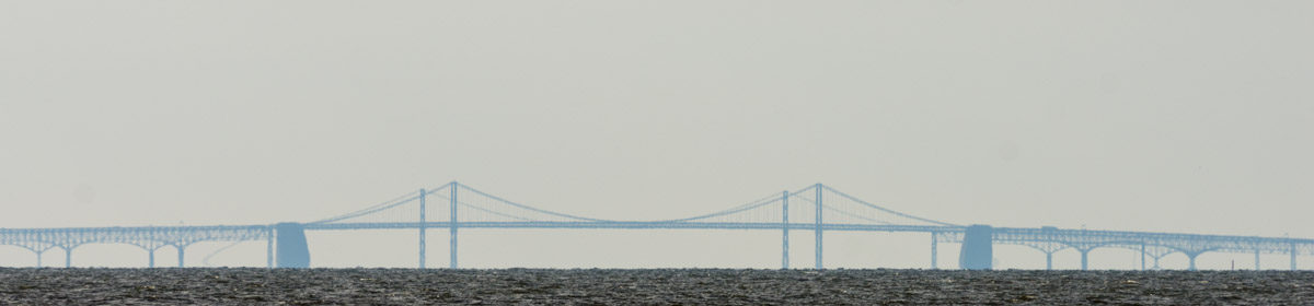
Prior to the opening of Maryland’s Chesapeake Bay Bridge, officially called the William Preston Lane, Jr., Memorial Bridge, in 1952 the only route across the Chesapeake Bay was through ferries. A parallel structure with three lanes was opened in 1973. These lanes are used for westbound traffic while the original 2-lane span is used for eastbound traffic. The shore-to-shore length of the Chesapeake Bay Bridge is 4.3 miles making it a long scenic over-water structure.
Since 1975, typically on an early Sunday in May, the eastbound span is closed to traffic and opened for use by walkers. This allows for a scenic view of the bridge and bay. At times the walk has been cancelled due to weather conditions and once, in 2002, for security reasons.
Across the mouth of the Chesapeake Bay where it meets the Atlantic Ocean there is The Chesapeake Bay Bridge-Tunnel, officially the Lucius J. Kellam, Jr. Bridge-Tunnel. Its shore-to-shore distance is 17.6 miles.
The Chesapeake Bay Bridge-Tunnel opened in 1964, and consists of more than 12 miles of low trestle bridges, two suspension bridges and two tunnels, each a mile long, under the shipping channels. It is considered the largest bridge-tunnel complex in the world.
The Chesapeake Bay is the largest estuary in the United States with more than 150 rivers and streams flowing into it. The name Chesapeake comes from the Algonquian word Chesepiooc, which is thought to mean “Great Shellfish Bay” or “Great Water. A recent scientific discovery theorizes that the bay was created by a meteor that hit the earth about 35.5 million years ago.
Nine of Maryland’s 23 counties are located on the peninsula. These being the counties of Kent, Queen Anne’s, Talbot, Caroline, Dorchester, Wicomico, Somerset, Worcester and a portion of Cecil County. The Virginia counties of Accomack and Northampton and the Delaware Counties of Kent, Sussex and a portion of New Castle County makes up the rest.
The 2000 census records the population residing in this area as 681,030 inhabitants.
The major part of the Delmarva Peninsula’s economy is through agriculture, aquaculture, sports hunting and fishing, and tourism.
 With a structure of life much different, at various times in its history the residents of the Maryland and Virginia portion of the peninsula have proposed that they should secede from their respective states and join Delaware to create a new state called Delmarva.